How it works from spotted to fixed
We bridge neighborhoods with the agencies that can help
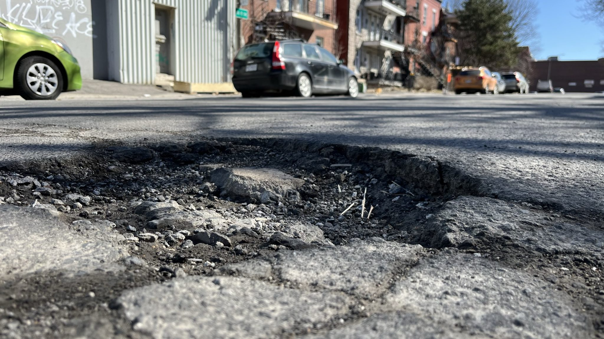

Spot an issue in your neighborhood
Notice a pothole, graffiti, broken streetlight, or illegal dumping? Simply pin a location and take a pic.

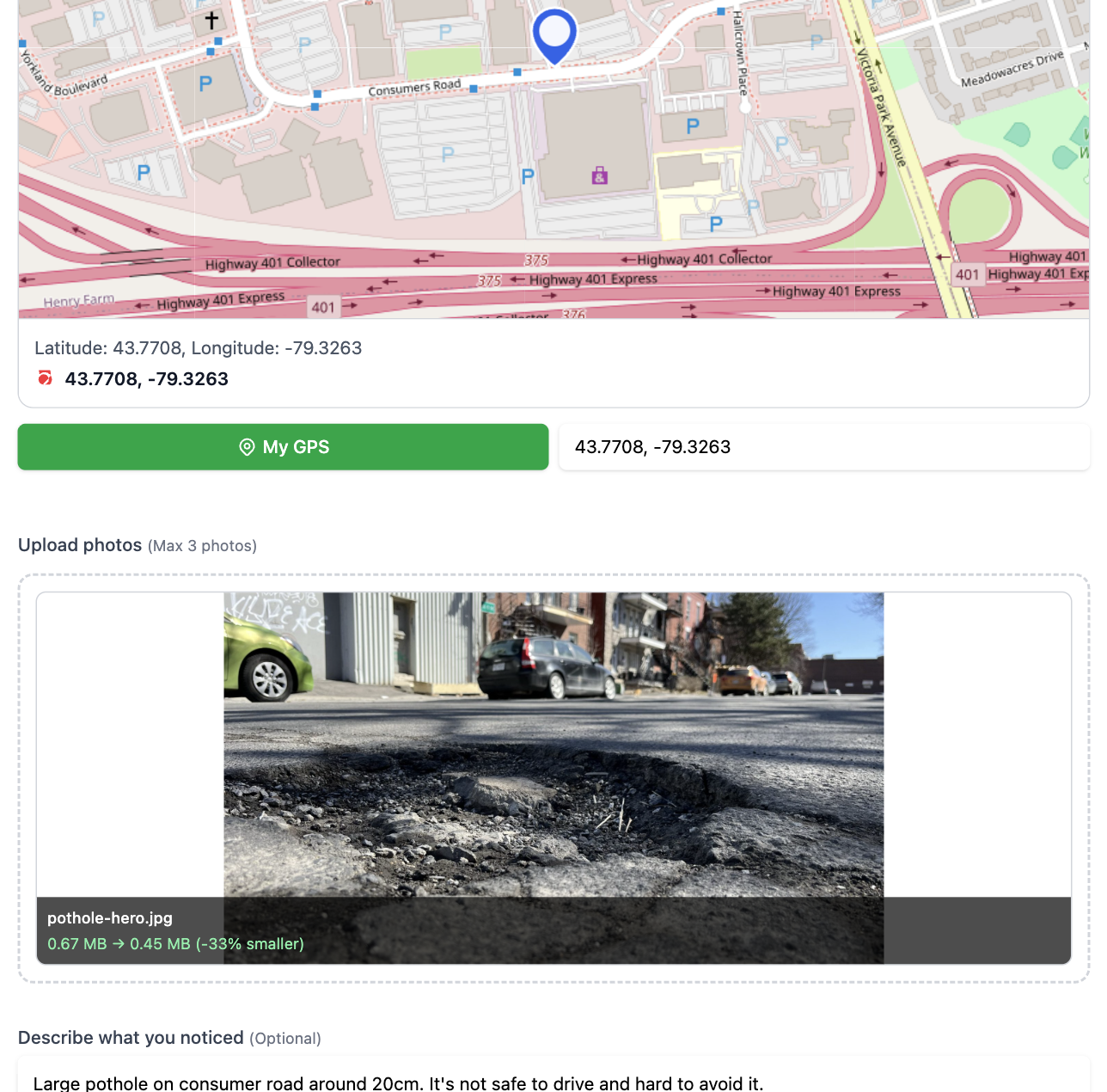
AI identifies the issue type
Our smart system analyzes your photo for issue type and drafts a report. You review it to be sent to the responsible authority.

They start fixing the problem
We make sure your report is sent to the city & your ward councillor and they start working on the problem.
What Can You Report?
See something broken in your neighborhood? You can report it here. Our AI recognizes 25+ different problems and sends your report to the right people at the city and your councillor.
Roads & Sidewalks
- • Potholes
- • Broken or damaged roads
- • Cracked sidewalks
- • Ice and snow buildup
- • Clogged storm drains
Street Stuff
- • Broken or dim street lights
- • Missing or damaged signs
- • Bus stop problems
- • Blocked wheelchair ramps
Garbage & Waste
- • Overflowing bins
- • Illegal dumping
- • Litter and debris
- • Dog poop
- • Dead animals
Graffiti & Vandalism
- • Graffiti
- • Illegal posters
- • Vandalized benches or bus stops
Parking & Vehicles
- • Illegal parking
- • Abandoned cars
- • Cars blocking sidewalks or bike lanes
- • Accessible parking issues
Parks & Trees
- • Broken playground equipment
- • Park maintenance problems
- • Fallen or dangerous trees
- • Overgrown plants blocking paths
- • Broken benches
Buildings & Property
- • Unsafe properties
- • Broken public washrooms
- • Dangerous building conditions
- • Abandoned buildings
Water & Flooding
- • Clogged drains
- • Water leaks
- • Flooding
- • Pooling water
Don't see what you need? Just take a photo and our AI will figure out what it is and where to send it.
Report an issueFrequently asked questions
For citizens
Do I need an account to submit a report?
Yes, you'll need to create a free account using your email and phone number. This allows us to send you updates about your report and helps verify that submissions are from real Toronto residents.
How does the AI know what type of issue I photographed?
Our AI analyzes visual patterns in your photo—like cracks in pavement, spray paint marks, or damaged infrastructure—and matches them to Toronto City 25+ issue categories. You always review and can adjust the suggestion before submitting.
What information do I need to provide?
Just a photo and location. The AI suggests the issue type and drafts a description, which you can edit. Optionally add extra details that might help the city respond faster.
Where does my report go?
Your report is automatically sent via email to the City of Toronto and your ward councillor. They receive a clear summary with your photo, description, and exact location.
Can I see if others reported the same issue?
Yes! Our community map shows all public reports in Toronto. You can see nearby issues, verify others' reports, and track when problems get fixed. This helps city teams prioritize based on community visibility.
What if my report is outside Toronto?
Currently, FixOurHood only serves Toronto. Reports outside city boundaries won't be routed to city services. We're working to expand to other Ontario municipalities—stay tuned!
How do I know if my issue was fixed?
You can mark your own report as resolved -after 24 hours-, or community members can submit resolution photos showing the fix. Resolved reports by admin display before/after photos.
Is my personal information shared?
No. Public reports on our map show only the issue type, location, and photo, no personal details unless you choose to add them in the description. Your phone number and email are only used for verification and account management.
For city officials
How do city departments receive reports?
Reports are sent via email to department-specific addresses (e.g., Transportation Services, Parks & Recreation) based on AI-detected issue type. Each email includes structured data: issue category, photo, GPS coordinates, and resident contact info.
How are reports verified for accuracy?
All users verify their phone number before submitting. Community members can "verify" reports they've seen firsthand, adding social validation. AI analyzes photos to categorize infrastructure issues and generate reports.
What information is included in each report?
Each report includes: issue category, GPS coordinates, street address, timestamp, high-res photo, AI-generated description (editable by user) and link to public map view.
How do ward councillors access reports in their ward?
Councillors receive automated emails for all reports within their ward boundaries. We're developing a councillor dashboard for filtering, tracking resolution rates, and exporting data for constituent communications if needed.
Can we respond to residents through the platform?
Not yet, but it's on our roadmap. For now, Admin can add report resolution notes to issue directly. Future updates will enable official resolution workflows so city teams can close tickets from their systems and have status sync to FixOurHood.
How do we mark a report as resolved?
Currently, residents or community members can updates the issue status by verifying a report and wheather it is fixed or not. Additionally, by uploading an "after" photo. We're building official resolution workflows so city teams can close tickets from their systems and have status sync to FixOurHood.
What if a report is misdirected or spam?
Contact us at "support @ fixourhood.ca" and we'll review and remove spam reports. For misdirected reports (wrong department), simply forward the email internally or let us know so we can improve AI routing accuracy.
Ready to Make a Difference?
Join thousands of Toronto residents using FixOurHood to care for our neighborhoods.